
← Features · Persons & Profiles
Photographic Pursuit Record — Persons & Profiles
Caleb Sloane
1837 – 1929
Pueblo, Colorado Territory — Weather Observer, Railroad Photographer, The First Tempest Photographer
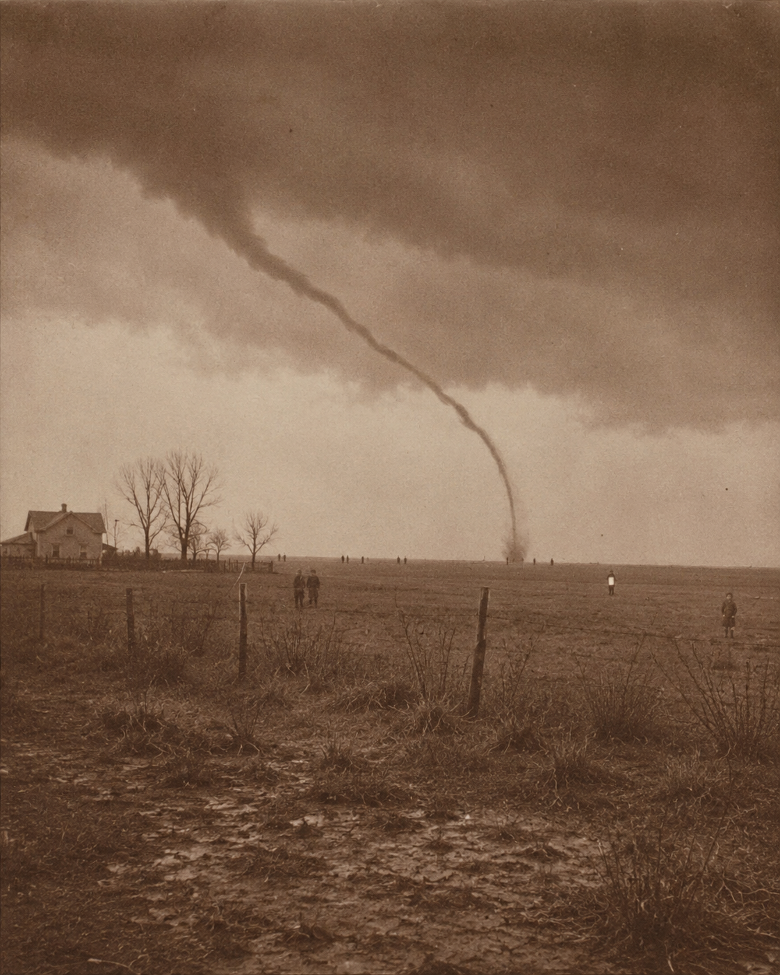
The Garnett Tornado — April 26, 1884 — Second plate, attributed C. Sloane — Westphalia, Kansas
Biographical
Caleb Sloane was born in 1837 in Pueblo, Colorado Territory, in the years before Colorado was American in any settled sense of the word. He was forty-seven years old when he made his now-disputed photograph of the April 26, 1884 Garnett, Kansas tornado. He lived until 1929 — long enough to hear weather reports on the radio, long enough to see the automobile replace the horse on the Santa Fe road he had traveled for forty years, long enough to watch the meteorological establishment gradually formalize the methods he had been practicing, without documentation and without acknowledgment, since the 1860s.
He worked as a railroad photographer throughout most of his career, documenting settlements, infrastructure, and depot towns along the Santa Fe corridor. He was, by all available accounts, reliable, competent, and invisible to the record in the ways that most working men of his period were invisible to the record.
The work he considered his primary occupation was the weather.
Weather Observation Practice
Sloane began systematic weather observation in 1868, though his deposition suggests informal recordkeeping as early as the early 1860s. By the time of the 1884 tornado, he had accumulated over fifteen years of daily observations in the Pueblo corridor and the surrounding elevated terrain, with particular focus on the Beulah corridor and the mountain front from Trinidad north to Colorado City.
His methodology was empirical and self-taught. He worked from Howard's cloud classification system, Signal Corps bulletins, and an informal correspondence network of observers along the railroad line. He maintained a prediction ledger — a running log of his severe-weather forecasts, checked against outcomes — that documented a success rate roughly double the official Signal Corps average over the same period. The ledger has not been located. Its contents are known only through his late-life deposition.
Sloane submitted his observations to the Signal Corps on at least two occasions. Neither submission generated a response beyond acknowledgment. He is not listed in any Signal Corps roster or volunteer observer network from the period. He described himself, in the deposition, as operating outside the institutional system by necessity rather than by preference: the system had no category for him.
Instrument Archive
Sloane documented his instrument kit across multiple deposition pages. The following were confirmed present at his Pueblo station or in his field kit at the time of the 1884 tornado:
- Aneroid BarometerField instrument, carried on all extended weather expeditions. Primary indicator for pressure drop rates preceding convective development.
- BarographSelf-recording pressure instrument, station use only. Produced paper rolls showing continuous pressure trace over time. Sloane retained all rolls from 1871 onward. Twelve years of barograph rolls are referenced in the deposition. None have been located.
- Sling PsychrometerWet-bulb / dry-bulb thermometer pair, used for humidity calculation. Sloane used comparative humidity measurements as a primary indicator for moisture availability in the low-level atmosphere preceding tornado events.
- Maximum / Minimum Thermometer SetThree-elevation array in the Beulah corridor, providing temperature gradient data across altitude. Non-standard placement; not replicable from Signal Corps records.
- Anemometer & Wind VaneStation instruments. Wind shift patterns — specifically backing winds at Trinidad — were among his primary precursor indicators for significant tornado events.
- Rain GaugeStandard station instrument. Used in conjunction with barograph traces to distinguish convective from stratiform precipitation events.
- Howard Cloud Classification ChartsAnnotated copy, with Sloane's own marginal extensions for mountain-front cloud behavior he designated "contact cloud." The annotated charts have not been located.
- Telegraph Correspondence NetworkInformal. La Junta stationmaster, Rocky Ford farmer correspondent, Trinidad telegraph operator. Real-time surface reports used to confirm regional conditions prior to storm pursuit. Not institutional; entirely self-assembled.
- Dry-Plate Camera & Field KitStandard professional photographic equipment consistent with the 1884 period. Capable of making multiple exposures on separate glass plates without immediate development. The camera, plates, and remaining equipment from 1884 are not in the collection.
Recovered Archive — Weather Log, April 1884 — C. Sloane, Pueblo
April 24, 1884 — Pueblo, Colorado Territory
Barograph: Falling. 29.84 to 29.71 in twelve hours. Rate of fall .011 per hour. Above the threshold I have associated with significant convective development in this corridor on three previous occasions.
Sling psychrometer: Dew point 48°F. For late April, this is elevated. The air is carrying more moisture than the season normally produces at this elevation.
Wind: South-southeast at approx. 9 mph. Backing. Backing is the tell. I have now documented this precursor in three of five previous tornado events in this region.
Telegraph from La Junta: "Sky green to the south this morning. Farmers are watching it." That phrase — farmers are watching it — has preceded two of my most significant storm observations.
The Signal Corps bulletin calls for scattered thunderstorms. This is insufficient. The system is not scattered. It is organized and moving northeast. My estimate places it in the Kansas corridor within 36 to 48 hours.
I am leaving Pueblo in the morning by rail east. I have enough plates for six exposures.
I intend to find it.
— C.S.
April 25, 1884 — Eastern Kansas, rail east of La Junta
Aneroid: 29.54 at noon. Dropping. The rate of fall has not slowed. The system is deepening faster than I projected.
Cloud base: low, greenish at the southwest margin. Air has the pressurized quality. A stillness that is not calm. Tomorrow.
— C.S.
April 26, 1884 — West of Westphalia, Kansas (Field Log)
Aneroid: 28.91 at 10 a.m. Dropping rapidly. Dew point elevated. Wind backing east to northeast. Cloud base approximately 2,000 feet. Green underside.
Funnel visible at 11:05 a.m., west-southwest, distance approx. 14 miles. Rope formation. Moving northeast, est. 15 mph. Narrow. Persistent. Classic rope for this latitude in late April.
Three exposures made: first at approx. 11:15, second at 11:20, third near end of visible phase as rope thinned toward the base of the main cloud.
Light quality exceptional. Yellow-green. The kind of light that makes everything look already documented.
— C.S.
May 10, 1884 — Pueblo, Development Room
Developed all three plates from the 26th today.
First plate: partial exposure, funnel at distance, blurred edges. Second plate: clean. Funnel centered, storm light correct. This is the plate I will submit.
Third plate. I examined it under the loupe for approximately one hour before writing this entry.
There are seven figures on the plate. They are standing in the road and along the fence. They have hard edges. They cast shadows in the correct direction. Two of them are behind the fence posts, properly occluded. They are inside the exposure.
They were not there. I was at that crossroads for forty minutes before the funnel appeared. I was alone. There was no one on that road for as far as I could see.
One of them is looking directly at my camera.
I am going to think about this for some time before I decide how to proceed.
— C.S.
The 1884 Event
On April 26, 1884, Caleb Sloane followed the storm system from Colorado into Kansas and photographed the Garnett tornado from a position west of Westphalia — making his first exposure at approximately 11:15 a.m., minutes before A. A. Adams photographed the same rope funnel from near Garnett as it continued northeast toward town. Adams's exposure was accepted. Sloane's second plate was submitted and returned as a duplicate of secondary interest. His third plate was rejected as evidence of damage or manipulation. Both plates were returned. Neither has been located.
The figures Sloane documented on his third plate are described in two separate written submissions (1884, 1885) and in his 1926 deposition. The descriptions are consistent across all three documents. The Obscura holds a transcription of the deposition. The original letters of submission have not been located in the Kansas photographic society archives or Signal Corps records.
The case is designated in the Temporal Anomaly Registry as TI–011.
Archive & Collection Status
Sloane spent the forty-five years after 1884 continuing his weather observation practice, maintaining logbooks and eventually drafting a manuscript almanac based on his accumulated data for the Pueblo corridor and the southern Colorado mountain front. He was, by the time of his 1926 deposition, the longest-running independent weather observer in the region — and one of the most scientifically systematic, by any reasonable measure.
His archive — twelve weather logbooks, illustrated cloud studies, barograph rolls from 1871 to approximately 1920, the prediction ledger, annotated cloud charts, and the draft almanac manuscript — was retained by his family after his death in 1929. It was held in family custody until approximately 1951, at which point the trail goes cold. No institutional archive, university collection, or historical society has confirmed acquisition of the Sloane materials. The Obscura's inquiry into the archive's current location is ongoing.
Related Records
- → 1st Person: The First Tempest Photographer — Sloane's account in full, from prediction through plate development and rejection
- → Temporal Anomaly Registry — The Sloane Plate, Case TI–011: seven figures in the road west of Westphalia
- → Regional Archive — Pueblo corridor and Beulah mountain-front locations documented in Sloane's observation network